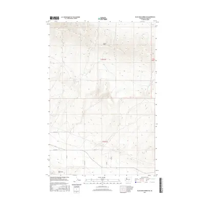
2017 Map of Black Rock Spring SW
USGS Topo · Published 2017About this map
Yakima Ridge dominates the northern half of this landscape, its steep contours rising above the dry drainage of Selah Cr in the northeast corner. This 2017 study of the high desert terrain in eastern Washington shows a land shaped by dramatic geological folds, with the Rattlesnake Hills anchoring the southwestern portion of the map. The human footprint is sparse, consisting primarily of a geometric grid of rural access roads that traverse the lower elevations between the ridges. These routes, including Den Beste Rd and Desmarais Rd, suggest a region defined by ranching or utility corridors. The detailed elevation data reveals the stark relief of the land, where named paths like Suntargets Rd and Moody Rd navigate the more accessible basins between these prominent basalt formations.
Find a feature on this map
10 named features on this map. Tap any name to fly to it.
Don’t see what you’re looking for? This feature index may not catch every label — zoom into the map to look around manually.
Map Details
Editions of this 2017 Black Rock Spring SW Map
This is the sole edition of this map. No revisions or reprints were ever made.
Other maps of this area

1910 · Zillah
USGS Topo · 1:125,000

1936 · Yakima East
USGS Topo · 1:48,000

1936 · Hog Ranch Buttes
USGS Topo · 1:48,000

1941 · Black Rock Spring
USGS Topo · 1:62,500

1941 · Yakima East
USGS Topo · 1:62,500

1950 · Yakima
USGS Topo · 1:250,000
1953 · Black Rock Spring NW
USGS Topo · 1:24,000
1953 · Black Rock Spring SW
USGS Topo · 1:24,000

1953 · Elephant Mountain
USGS Topo · 1:24,000
1953 · Black Rock Spring
USGS Topo · 1:24,000