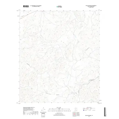
2019 Map of Black Waterhole
USGS Topo · Published 2019About this map
W Nueces River carves a deep valley through this Edwards County landscape, defining the local geography alongside drainage systems like Geronimo Cr and Possum Cr. The map captures a rugged portion of the Texas Hill Country where water is the primary architect of the terrain, seen in the numerous basins such as Crooked Draw, Cedar Draw, and the wider Jackson Flat. Human movement through this environment is dictated by these natural contours, with Bracketville Hwy 674 and Old US Hwy 377 skirting the higher ground. Local water sources, historically vital in this arid region, are documented at Silman Spring and Silman Springs, providing essential points of interest for those studying the early ranching and settlement patterns of the Southwest.
Find a feature on this map
16 named features on this map. Tap any name to fly to it.
Don’t see what you’re looking for? This feature index may not catch every label — zoom into the map to look around manually.
Map Details
Editions of this 2019 Black Waterhole Map
This is the sole edition of this map. No revisions or reprints were ever made.
Other maps of this area

1893 · Rock Springs
USGS Topo · 1:125,000

1893 · Nueces
USGS Topo · 1:125,000

1896 · Nueces
USGS Topo · 1:125,000

1943 · Carta Valley
USGS Topo · 1:62,500

1944 · Indian Creek
USGS Topo · 1:62,500

1954 · Sonora
USGS Topo · 1:250,000

1958 · Sonora
USGS Topo · 1:250,000

1958 · Del Rio
USGS Topo · 1:250,000

1964 · Del Rio
USGS Topo · 1:250,000
1971 · Ray Lake SE
USGS Topo · 1:24,000