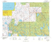
1976 Map of Blackduck
USGS Topo · Published 1978About this map
Lower Red Lake and the Red Lake Indian Reservation anchor the northwestern portion of this mid-1970s survey, illustrating a landscape defined by expansive wetlands and timber management. The region's transport and industrial roots are visible in the tracks of the Northern Pacific and Burlington Northern railroads, which connected timber outposts and small agricultural centers. Several lookout towers, including the Northome Lookout Tower and Blackduck Lookout Tower, reflect the active forest fire surveillance system within the Chippewa National Forest and surrounding state forests.
Find a feature on this map
85 named features on this map. Tap any name to fly to it.
Don’t see what you’re looking for? This feature index may not catch every label — zoom into the map to look around manually.
Map Details
Editions of this 1976 Blackduck Map
This is the sole edition of this map. No revisions or reprints were ever made.
Other maps of this area

1918 · Zora
USGS Topo · 1:62,500

1919 · Rosy
USGS Topo · 1:62,500

1919 · Zora
USGS Topo · 1:62,500

1919 · Lundgren
USGS Topo · 1:62,500

1919 · Fox
USGS Topo · 1:62,500

1919 · Gemmell
USGS Topo · 1:62,500

1919 · Solway
USGS Topo · 1:62,500

1919 · Quiring
USGS Topo · 1:62,500

1919 · Max
USGS Topo · 1:62,500

1919 · Norden
USGS Topo · 1:62,500