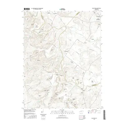
2016 Map of Blackford
USGS Topo · Published 2016About this map
The Tradewater River winds through the borderlands of Crittenden, Union, and Webster Counties, anchoring a landscape where river bottoms meet prominent local heights. Small settlements like Blackford, Sullivan, and Derby are connected by a network of rural routes, including the Hiwater road and Old Sullivan Rd. The area is characterized by family-named terrain features such as Bob Lee Phillips Hill, McGraw Hill, and Arflack Hill, suggesting deep generational ties to the land.
Find a feature on this map
118 named features on this map. Tap any name to fly to it.
Don’t see what you’re looking for? This feature index may not catch every label — zoom into the map to look around manually.
Map Details
Editions of this 2016 Blackford Map
This is the sole edition of this map. No revisions or reprints were ever made.
Other maps of this area

1907 · Morganfield
USGS Topo · 1:62,500

1909 · Providence
USGS Topo · 1:62,500

1916 · Shawneetown
USGS Topo · 1:62,500

1916 · Fords Ferry
USGS Topo · 1:62,500

1921 · Fords Ferry
USGS Topo · 1:48,000

1925 · Cave In Rock
USGS Topo · 1:62,500

1949 · Paducah
USGS Topo · 1:250,000

1950 · Paducah
USGS Topo · 1:250,000
1951 · Bordley
USGS Topo · 1:24,000

1951 · Sturgis
USGS Topo · 1:24,000