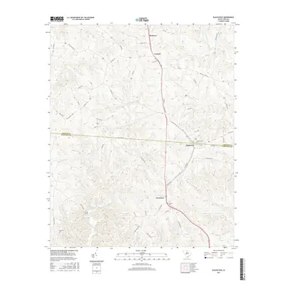
2017 Map of Blackstock
USGS Topo · Published 2017About this map
Blackstock and Woodward anchor this landscape along the border of Chester and Fairfield Counties, where the Piedmont terrain begins to roll toward the Big Wateree Cr drainage. This modern survey illustrates the enduring rural structure of the South Carolina backcountry, where settlement remains concentrated along the north-south axis of Columbia Rd. The network of creeks including Little River, Mobley Cr, and Little Rocky Cr defines the local topography, carving shallow valleys that historical road patterns like Cornwell Rd and Ashford Rd still navigate today.
Find a feature on this map
55 named features on this map. Tap any name to fly to it.
Don’t see what you’re looking for? This feature index may not catch every label — zoom into the map to look around manually.
Map Details
Editions of this 2017 Blackstock Map
This is the sole edition of this map. No revisions or reprints were ever made.
Other maps of this area

1904 · Columbia
USGS Topo · 1:125,000

1941 · Spartanburg
USGS Topo · 1:250,000

1953 · Spartanburg
USGS Topo · 1:250,000

1960 · Spartanburg
USGS Topo · 1:250,000

1963 · Spartanburg
USGS Topo · 1:250,000

1964 · Spartanburg
USGS Topo · 1:250,000

1968 · Blackstock
USGS Topo · 1:24,000

1969 · Lebanon
USGS Topo · 1:24,000
1969 · Salem Crossroads
USGS Topo · 1:24,000
1969 · Winnsboro
USGS Topo · 1:24,000