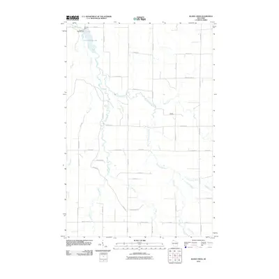
2010 Map of Blaine Creek
USGS Topo · Published 2010About this map
The Iron River and its intricate tributaries define this Northwoods landscape in Bayfield County, where the river system converges at the Orienta Flowage 148. Regulated by the Orienta Dam and the Port Wing 2WP954 Dam, the water network reaches across the quadrangle through the East Fork Iron River, Blaine Creek, and Resch Creek. The map documents a rural infrastructure of family-named roads, such as Gulu Pedersen Rd, Hokkanen Rd, and Raivala Rd, which reflect the region's cultural heritage. Hillside Cemetery stands as a primary landmark for genealogists, situated along Evergreen Rd north of the winding Kolin Creek. This 2010 survey illustrates the persistence of a remote logging and agricultural grid, where the headwaters of Muskeg Creek and Hill Creek transition into a landscape of dense drainage patterns flowing toward Lake Superior.
Find a feature on this map
44 named features on this map. Tap any name to fly to it.
Don’t see what you’re looking for? This feature index may not catch every label — zoom into the map to look around manually.
Map Details
Editions of this 2010 Blaine Creek Map
This is the sole edition of this map. No revisions or reprints were ever made.
Other maps of this area

1943 · Port Wing
USGS Topo · 1:48,000

1943 · Iron Lake
USGS Topo · 1:48,000

1946 · Port Wing
USGS Topo · 1:48,000

1947 · Brule
USGS Topo · 1:48,000

1947 · Iron Lake
USGS Topo · 1:48,000

1953 · Ashland
USGS Topo · 1:250,000

1958 · Ashland
USGS Topo · 1:250,000

1961 · Iron Lake SW
USGS Topo · 1:24,000
1961 · Iron Lake
USGS Topo · 1:62,500
1961 · Port Wing
USGS Topo · 1:62,500