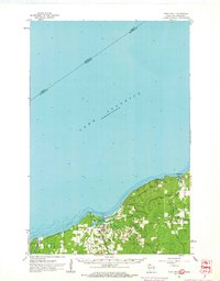
1961 Map of Port Wing
USGS Topo · Published 1963About this map
Lake Superior dominates the northern half of this coastal landscape, where the waters meet the shoreline of Port Wing and Clover. The 1961 survey captures the area’s dependence on the lake and its immediate tributaries, centered on the protected waters of Bibon Lake and the mouth of the Flag River. While the small settlement of Port Wing serves as a primary hub, the map also details the smaller community of Herbster to the northeast. Interior land use is reflected in several Gravel Pits and a Quarry near the coast, indicating local industry during the early 1960s. The drainage patterns of the West Fork Cranberry River and East Fork Cranberry River illustrate the heavily wooded, creek-fed terrain characteristic of this Bayfield County region, with State Route 13 providing the primary corridor through the settlements.
Find a feature on this map
20 named features on this map. Tap any name to fly to it.
Don’t see what you’re looking for? This feature index may not catch every label — zoom into the map to look around manually.
Map Details
Editions of this 1961 Port Wing Map
2 editions found
Other maps of this area

1943 · Port Wing
USGS Topo · 1:48,000

1943 · Iron Lake
USGS Topo · 1:48,000

1944 · Moquah
USGS Topo · 1:48,000

1944 · Cornucopia
USGS Topo · 1:48,000

1946 · Cornucopia
USGS Topo · 1:48,000

1946 · Port Wing
USGS Topo · 1:48,000

1947 · Moquah
USGS Topo · 1:48,000

1947 · Brule
USGS Topo · 1:48,000

1947 · Iron Lake
USGS Topo · 1:48,000

1953 · Ashland
USGS Topo · 1:250,000