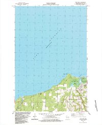
1984 Map of Port Wing
USGS Topo · Published 1984About this map
Lake Superior dominates the northern horizon of this coastal survey, where the Flag River and Iron River meet the south shore of the bay. The settlement of Port Wing serves as the focal point, situated near the protected waters of Bibon Lake and the Flag River State Fishery Area. This 1980s landscape shows a community defined by its proximity to the water and a network of rural roads like Old Highway 13 and Townhall Road that connect outlying homesteads to the village core. Local institutions such as the South Shore High Sch and Greenwood Cem appear alongside coastal landmarks like Quarry Point and a lakeside Light. The map records a quiet era of northern Wisconsin life, where the interior remains largely wooded, punctuated only by a few Gravel Pit sites and small settlements like Orienta.
Find a feature on this map
25 named features on this map. Tap any name to fly to it.
Don’t see what you’re looking for? This feature index may not catch every label — zoom into the map to look around manually.
Map Details
Editions of this 1984 Port Wing Map
This is the sole edition of this map. No revisions or reprints were ever made.
Other maps of this area

1943 · Port Wing
USGS Topo · 1:48,000

1943 · Iron Lake
USGS Topo · 1:48,000

1946 · Port Wing
USGS Topo · 1:48,000

1947 · Brule
USGS Topo · 1:48,000

1947 · Iron Lake
USGS Topo · 1:48,000

1953 · Ashland
USGS Topo · 1:250,000

1958 · Ashland
USGS Topo · 1:250,000
1961 · Iron Lake
USGS Topo · 1:62,500
1961 · Port Wing
USGS Topo · 1:62,500
1961 · Brule
USGS Topo · 1:62,500