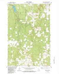
1984 Map of Blaine Creek
USGS Topo · Published 1984About this map
The Iron River winds through this section of Bayfield County, dominated by the township divisions of Orienta, Oulu, Port Wing, and Tripp. In the northern portion of the map, the Orienta Dam regulates the river's flow near a dedicated Public Access point. This 1980s landscape is defined by a dense network of local roads named for early families and settlers, including Severson Road, Sorenson Road, and Carlson Road.
Find a feature on this map
33 named features on this map. Tap any name to fly to it.
Don’t see what you’re looking for? This feature index may not catch every label — zoom into the map to look around manually.
Map Details
Editions of this 1984 Blaine Creek Map
This is the sole edition of this map. No revisions or reprints were ever made.
Other maps of this area

1943 · Port Wing
USGS Topo · 1:48,000

1943 · Iron Lake
USGS Topo · 1:48,000

1946 · Port Wing
USGS Topo · 1:48,000

1947 · Brule
USGS Topo · 1:48,000

1947 · Iron Lake
USGS Topo · 1:48,000

1953 · Ashland
USGS Topo · 1:250,000

1958 · Ashland
USGS Topo · 1:250,000

1961 · Iron Lake SW
USGS Topo · 1:24,000
1961 · Iron Lake
USGS Topo · 1:62,500
1961 · Port Wing
USGS Topo · 1:62,500