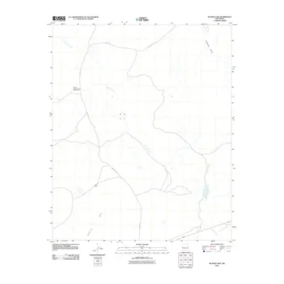
2010 Map of Blaines Lake
USGS Topo · Published 2010About this map
Agua Fria Creek meanders through this high-altitude landscape of western New Mexico, feeding into the small basin of Blaines Lake near the southeastern corner of the sheet. The terrain is defined by wide desert reaches and structural landforms like Cimarron Mesa and Cottonwood Canyon. Human intervention in the arid environment is evidenced by water management infrastructure, specifically Red Hill Detention Dam Number One and Perea Dam, which serve to control runoff and support the livestock and ranching activities that characterize this part of Catron County. The primary arterial route, County Rd-A7, provides the essential connection across the sparse high-desert topography during this early 21st-century period.
Find a feature on this map
7 named features on this map. Tap any name to fly to it.
Don’t see what you’re looking for? This feature index may not catch every label — zoom into the map to look around manually.
Map Details
Editions of this 2010 Blaines Lake Map
This is the sole edition of this map. No revisions or reprints were ever made.
Other maps of this area

1954 · Saint Johns
USGS Topo · 1:250,000

1955 · Red Hill
USGS Topo · 1:24,000

1957 · Saint Johns
USGS Topo · 1:250,000

1958 · Saint Johns
USGS Topo · 1:250,000

1962 · Saint Johns
USGS Topo · 1:250,000

1972 · Zuni Salt Lake
USGS Topo · 1:24,000

1972 · Lake Armijo
USGS Topo · 1:24,000
1972 · Red Hill
USGS Topo · 1:24,000

1972 · Blaines Lake
USGS Topo · 1:24,000
1972 · Cow Springs
USGS Topo · 1:24,000