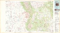
1982 Map of Blanca Peak
USGS Topo · Published 1983About this map
The Sangre de Cristo Mountains dominate this 1980s landscape, serving as a massive physical barrier between the San Luis Valley and the plains to the east. High alpine summits like Blanca Peak and Crestone Peak overlook the shifting geography of the Great Sand Dunes National Monument and Wilderness, while the sprawling Luis Maria Baca No 4 land grant marks a significant historical land use pattern in the north. Settlement is concentrated along the transport corridors, with the Denver and Rio Grande Western railroad skirting the valley floor near Mosca and Hooper. On the eastern slopes, small communities like Gardner and Red Wing follow the course of the Huerfano River, illustrating a transition from the high peaks to the lower river valleys. The presence of an Old Railroad Grade near Muleshoe suggests the evolution of mountain transit during this era.
Find a feature on this map
66 named features on this map. Tap any name to fly to it.
Don’t see what you’re looking for? This feature index may not catch every label — zoom into the map to look around manually.
Map Details
Editions of this 1982 Blanca Peak Map
2 editions found
Other maps of this area

1889 · Canon City
USGS Topo · 1:125,000

1889 · Huerfano Park
USGS Topo · 1:125,000

1891 · Walsenburg
USGS Topo · 1:125,000

1891 · Pueblo
USGS Topo · 1:125,000

1891 · Spanish Peaks
USGS Topo · 1:125,000

1892 · Huerfano Park
USGS Topo · 1:125,000

1892 · Canon City
USGS Topo · 1:125,000

1893 · Spanish Peaks
USGS Topo · 1:125,000

1894 · Walsenburg
USGS Topo · 1:125,000

1894 · Pueblo
USGS Topo · 1:125,000