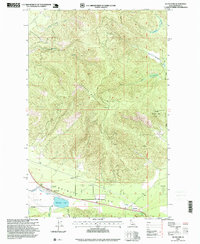
1996 Map of Blanchard
USGS Topo · Published 1999About this map
Spirit Valley serves as the focal point of this North Idaho landscape, where the settlement of Blanchard sits along the banks of Blanchard Creek. The terrain is dominated by the massive rise of Hoodoo Mountain, which transitions into the protected timberlands of the Kaniksu National Forest. This 1990s revision captures the area's rural character, showing the distribution of small farms and clearings against the dense forest cover of the Panhandle. Local history is anchored at the Pine Grove Cemetery and the small siding at Coleman, while the presence of a Bike Course and a Golf Course indicates the area's mid-century shift toward recreation. Hydrological patterns are clearly defined by Blanchard Lake and the drainage of Spirit Creek, tracing the natural paths through the high country toward the First Guide Meridian West.
Find a feature on this map
23 named features on this map. Tap any name to fly to it.
Don’t see what you’re looking for? This feature index may not catch every label — zoom into the map to look around manually.
Map Details
Editions of this 1996 Blanchard Map
This is the sole edition of this map. No revisions or reprints were ever made.
Other maps of this area

1901 · Sandpoint
USGS Topo · 1:125,000

1901 · Spokane
USGS Topo · 1:125,000

1903 · Rathdrum
USGS Topo · 1:125,000

1911 · Priest Lake
USGS Topo · 1:250,000

1911 · Sandpoint
USGS Topo · 1:125,000

1913 · Priest Lake
USGS Topo · 1:250,000

1936 · Newport
USGS Topo · 1:96,000

1942 · Newport
USGS Topo · 1:125,000

1943 · Mt Spokane
USGS Topo · 1:62,500

1950 · Mt Spokane
USGS Topo · 1:62,500