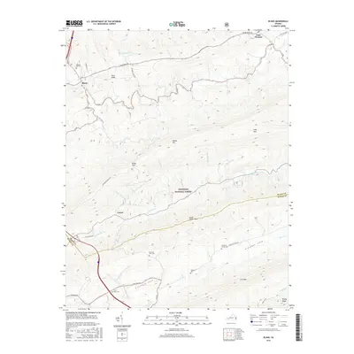
2016 Map of Bland
USGS Topo · Published 2016About this map
Bland serves as a primary settlement within this Virginia landscape, situated near the headwaters of Walker Creek and south of Town Ridge. The terrain is defined by the steep, parallel ridges of Walker Mtn and Little Walker Mtn, which frame the valley containing the Jefferson National Forest. For genealogists and local historians, the sheet is particularly dense with family-named landmarks and burial sites, including Temple Hill Cem, Mountain View Cem, and Crockett Cem. Further south, the map details the secluded Crockett Cove area, anchored by The Brick Church Cem and Saint Lukes Cem. Smaller settlements like Point Pleasant and Carnot are connected by a network of local routes such as Walkers Creek Rd and State Rte 656, reflecting a traditional Appalachian land-use pattern where homesteads follow the narrow creek bottoms like Helveys Mill Cr and Little Walker Cr.
Find a feature on this map
51 named features on this map. Tap any name to fly to it.
Don’t see what you’re looking for? This feature index may not catch every label — zoom into the map to look around manually.
Map Details
Editions of this 2016 Bland Map
This is the sole edition of this map. No revisions or reprints were ever made.
Other maps of this area

1887 · Pocahontas
USGS Topo · 1:125,000

1889 · Hillsville
USGS Topo · 1:125,000

1889 · Wytheville
USGS Topo · 1:125,000

1890 · Dublin
USGS Topo · 1:125,000

1891 · Pocahontas
USGS Topo · 1:125,000

1891 · Dublin
USGS Topo · 1:125,000

1892 · Hillsville
USGS Topo · 1:125,000

1892 · Wytheville
USGS Topo · 1:125,000

1894 · Pocahontas
USGS Topo · 1:125,000

1895 · Pocahontas
USGS Topo · 1:125,000