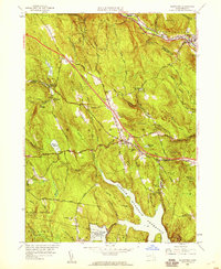
1955 Map of Blandford
USGS Topo · Published 1959About this map
The hills of western Hampden County are bisected by the Massachusetts Turnpike and the Boston and Albany railroad corridor in this mid-1950s survey. The landscape is defined by significant water management infrastructure, most notably the expansive Cobble Mountain Reservoir and the Borden Brook Reservoir. These engineered basins sit within a network of peaks like Dug Hill and Sunapee Hill, where the transition from traditional stage roads to modern infrastructure is clearly visible. The General Knox Stage Trail winds through the Blandford State Forest, offering a glimpse into the colonial-era routes that once connected these upland settlements. Local history is preserved in the locations of the North Blandford Cem and Warfield Cem, while the industrial footprint of the era is marked by a Gravel Quarry and dedicated Service Facilities along the turnpike near the village of Blandford.
Find a feature on this map
95 named features on this map. Tap any name to fly to it.
Don’t see what you’re looking for? This feature index may not catch every label — zoom into the map to look around manually.
Map Details
Editions of this 1955 Blandford Map
3 editions found
Other maps of this area

1886 · Chesterfield
USGS Topo · 1:62,500

1886 · Becket
USGS Topo · 1:62,500

1887 · Granville
USGS Topo · 1:62,500

1888 · Becket
USGS Topo · 1:62,500

1888 · Sandisfield
USGS Topo · 1:62,500

1888 · Chesterfield
USGS Topo · 1:62,500

1889 · Granville
USGS Topo · 1:62,500

1893 · Granville
USGS Topo · 1:62,500

1893 · Chesterfield
USGS Topo · 1:62,500

1893 · Becket
USGS Topo · 1:62,500