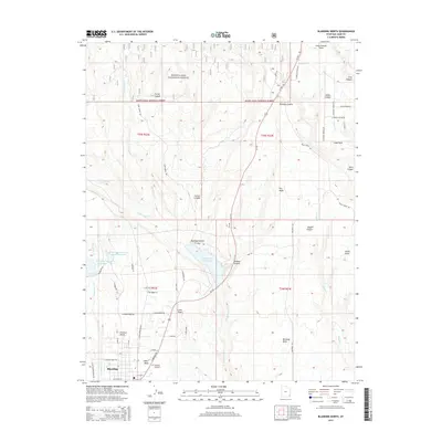
2014 Map of Blanding North
USGS Topo · Published 2014About this map
The town of Blanding anchors this section of southeastern Utah, showing the residential grid and local landmarks like the Blanding City Cem. This 2014 survey documents the complex water management system essential to this high-desert region, featuring the large Recapture Reservoir and the Blanding City Reservoirs situated to the north. The landscape transitions from the developed streets of White Mesa to the protected woodlands of the Manti-Lasal National Forest. Significant topographical features define the eastern and northern reaches of the map, including Mustang Mesa, Alkali Canyon, and the prominent Long Canyon Point. Local transit is centered on Us-191, which connects these canyon-dissected plateaus, while smaller roads like N Grayson Pky and Dude Ranch Rd provide access to more remote locations such as The Park and Pinenut Knoll.
Find a feature on this map
58 named features on this map. Tap any name to fly to it.
Don’t see what you’re looking for? This feature index may not catch every label — zoom into the map to look around manually.
Map Details
Editions of this 2014 Blanding North Map
This is the sole edition of this map. No revisions or reprints were ever made.
Other maps of this area

1886 · Abajo
USGS Topo · 1:250,000

1892 · Abajo
USGS Topo · 1:250,000

1893 · Abajo
USGS Topo · 1:250,000

1935 · Elk Ridge
USGS Topo · 1:96,000

1940 · Elk Ridge
USGS Topo · 1:125,000

1954 · Elk Ridge 1 SE
USGS Topo · 1:24,000
1954 · Mt Linnaeus
USGS Topo · 1:62,500

1955 · Verdure 2 SE
USGS Topo · 1:24,000

1955 · Verdure 3 SE
USGS Topo · 1:24,000

1955 · Verdure 3 NE
USGS Topo · 1:24,000