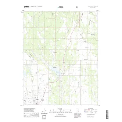
2020 Map of Blanding North
USGS Topo · Published 2020About this map
Blanding serves as the primary hub in this southeastern Utah landscape, situated just west of the White Mesa settlement. The terrain transitions from the high elevations of the Manti-La Sal National Forest in the north down toward the extensive canyon systems that define the region. Water management is a central theme, evidenced by the Recapture Reservoir and the Blanding City Number Three Reservoir, which support the local community amidst the arid environment of Mustang Mesa and The Park. This survey provides a clear view of the road network that connects these isolated settlements, including N Grayson Pkwy and N Reservoir Rd. Genealogists can locate the Blanding City Cem on the outskirts of town, while the surrounding topography is marked by numerous natural landmarks such as Pinenut Knoll, Bullpup Canyon, and Alkali Canyon.
Find a feature on this map
41 named features on this map. Tap any name to fly to it.
Don’t see what you’re looking for? This feature index may not catch every label — zoom into the map to look around manually.
Map Details
Editions of this 2020 Blanding North Map
This is the sole edition of this map. No revisions or reprints were ever made.
Other maps of this area

1886 · Abajo
USGS Topo · 1:250,000

1892 · Abajo
USGS Topo · 1:250,000

1893 · Abajo
USGS Topo · 1:250,000

1935 · Elk Ridge
USGS Topo · 1:96,000

1940 · Elk Ridge
USGS Topo · 1:125,000

1954 · Elk Ridge 1 SE
USGS Topo · 1:24,000
1954 · Mt Linnaeus
USGS Topo · 1:62,500

1955 · Verdure 2 SE
USGS Topo · 1:24,000

1955 · Verdure 3 SE
USGS Topo · 1:24,000

1955 · Verdure 3 NE
USGS Topo · 1:24,000