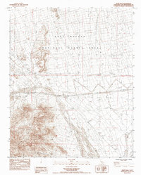
1984 Map of Blind Hills
USGS Topo · Published 1984About this map
The Clipper Mountains dominate the southwestern corner of this desert landscape, where water management is defined by the isolated Hummingbird Spring. This 1984 survey of the East Mojave National Scenic Area reveals a terrain of vast alluvial systems, most notably the Black Canyon Wash and the Fenner Valley Wash that drain the high ground. Evidence of historic desert industry is centered on the Goldhammer Mine in the northern reaches, while long spans of Fence lines trace the division of the open range. Early transportation corridors like Essex Road and Hidden Hill Road connect these remote landmarks, providing a record of human passage through the Blind Hills and Clipper Valley Wash during the late twentieth century.
Find a feature on this map
12 named features on this map. Tap any name to fly to it.
Don’t see what you’re looking for? This feature index may not catch every label — zoom into the map to look around manually.
Map Details
Editions of this 1984 Blind Hills Map
This is the sole edition of this map. No revisions or reprints were ever made.
Other maps of this area

1942 · Amboy
USGS Topo · 1:250,000

1943 · Amboy
USGS Topo · 1:250,000

1943 · Essex
USGS Topo · 1:62,500

1943 · Danby
USGS Topo · 1:62,500

1943 · Fenner
USGS Topo · 1:62,500

1954 · Needles
USGS Topo · 1:250,000

1956 · Needles
USGS Topo · 1:250,000

1956 · Fenner
USGS Topo · 1:62,500

1956 · Essex
USGS Topo · 1:62,500

1956 · Colton Well
USGS Topo · 1:62,500