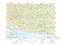
1968 Map of Blind River
USGS Topo · Published 1968About this map
The North Channel of Lake Huron serves as the dominant geographic feature of this 1968 regional survey, delineating the international border between Ontario and Drummond Island, Michigan. This coastal corridor is defined by the logistics of the Canadian Pacific railroad and Highway 17, which connect a series of waterfront settlements including Thessalon, Blind River, and Spanish. The inland landscape is characterized by the expansive Mississagi Provincial Forest and an intricate network of water bodies such as Wakomata Lake and Chiblow Lake. The map reveals the industrial and recreational layout of the late 1960s, noting the development near Elliot Lake and the various drainage basins of the Mississagi River and Serpent River that flow south toward the Great Lakes.
Find a feature on this map
40 named features on this map. Tap any name to fly to it.
Don’t see what you’re looking for? This feature index may not catch every label — zoom into the map to look around manually.
Map Details
Editions of this 1968 Blind River Map
This is the sole edition of this map. No revisions or reprints were ever made.
Other maps of this area

1919 · Neebish
USGS Topo · 1:62,500

1941 · Neebish
USGS Topo · 1:63,360

1951 · Lake George
USGS Topo · 1:62,500

1953 · Munuscong NE
USGS Topo · 1:24,000

1954 · Alpena
USGS Topo · 1:250,000

1954 · Sault Sainte Marie
USGS Topo · 1:250,000

1955 · Cheboygan
USGS Topo · 1:250,000

1956 · Sault Sainte Marie
USGS Topo · 1:250,000

1957 · Alpena
USGS Topo · 1:250,000

1957 · Sault Sainte Marie
USGS Topo · 1:250,000