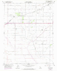
1960 Map of Bliss Ranch
USGS Topo · Published 1978About this map
The agricultural landscape of Merced and Madera Counties is defined by a sophisticated network of water management and large land holdings. Large ranching operations like the Chowchilla Ranch and Bliss Ranch anchor the region, while the Chowchilla River and Ash Slough provide the natural drainage skeleton for the territory. The presence of the Eastside Bypass and various man-made channels such as the Justin Canal and Hughes Canal illustrates the mid-century engineering required to sustain this valley's productivity. Rural social centers are visible through the Alamo School and Ashview School, serving the families concentrated around local hubs like Red Top. The inclusion of the Red Top Airport and scattered Gas Well sites indicates a diversified economy where aviation and resource extraction supported the primary ranching and farming operations.
Find a feature on this map
58 named features on this map. Tap any name to fly to it.
Don’t see what you’re looking for? This feature index may not catch every label — zoom into the map to look around manually.
Map Details
Editions of this 1960 Bliss Ranch Map
3 editions found
Other maps of this area

1913 · Panoche
USGS Topo · 1:125,000

1916 · Santa Rita Bridge
USGS Topo · 1:24,000

1918 · Bliss Ranch
USGS Topo · 1:31,680

1918 · Lingard
USGS Topo · 1:31,680

1918 · Chowchilla
USGS Topo · 1:31,680

1918 · Sandy Mush
USGS Topo · 1:31,680

1919 · Plainsberg
USGS Topo · 1:31,680

1920 · Santa Rita Bridge
USGS Topo · 1:31,680

1922 · Oxalis
USGS Topo · 1:31,680

1922 · Santa Rita Bridge
USGS Topo · 1:31,680