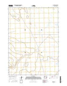
2017 Map of Blitzen
USGS Topo · Published 2017About this map
Blitzen sits within the expanse of the Catlow Valley in this southeastern Oregon survey, reflecting the remote ranching and grazing landscape of Harney County. The area is defined by its wide, flat valley floor and the essential north-south corridor of Blitzen Valley Rd, which connects the sparse settlements of this high desert region. The mapping emphasizes the Public Land Survey System grid, including townships t34s r31e, t34s r32e, t35s r31e, and t35s r32e, which historically organized the distribution of land in this part of the state. While the landscape appears open, the presence of these surveyed sections and the single primary road underscores the long-standing importance of land management and access in the high desert's agricultural history.
Find a feature on this map
7 named features on this map. Tap any name to fly to it.
Don’t see what you’re looking for? This feature index may not catch every label — zoom into the map to look around manually.
Map Details
Editions of this 2017 Blitzen Map
This is the sole edition of this map. No revisions or reprints were ever made.
Other maps of this area

1955 · Adel
USGS Topo · 1:250,000

1957 · Adel
USGS Topo · 1:250,000

1958 · Adel
USGS Topo · 1:250,000

1962 · Adel
USGS Topo · 1:250,000

1967 · Roaring Springs
USGS Topo · 1:24,000

1971 · Fish Fin Rim
USGS Topo · 1:24,000

1971 · Blitzen
USGS Topo · 1:24,000

1971 · Garrison Lake
USGS Topo · 1:24,000

1971 · Butler Hill
USGS Topo · 1:24,000
1971 · Coyote Gap
USGS Topo · 1:24,000