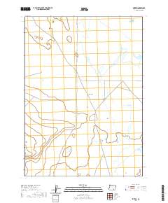
2020 Map of Blitzen
USGS Topo · Published 2020About this map
Catlow Valley dominates this high-desert landscape in southeastern Harney County, characterized by its wide, open reaches and sparse settlement. The small community of Blitzen serves as a primary point of reference in this arid basin, a region defined by its isolation and the vast public land tracts of the American West. Cutting north to south through the terrain, Blitzen Valley Rd provides the essential transit corridor connecting this remote pocket of Oregon to the wider world. The map detail reflects the enduring grid of the Public Land Survey System, with township and range boundaries such as t34s r31e and t35s r31e framing the open landscape. This 2020 record preserves the contemporary footprint of a place where the geography of the Great Basin remains the most prominent feature.
Find a feature on this map
7 named features on this map. Tap any name to fly to it.
Don’t see what you’re looking for? This feature index may not catch every label — zoom into the map to look around manually.
Map Details
Editions of this 2020 Blitzen Map
This is the sole edition of this map. No revisions or reprints were ever made.
Other maps of this area

1955 · Adel
USGS Topo · 1:250,000

1957 · Adel
USGS Topo · 1:250,000

1958 · Adel
USGS Topo · 1:250,000

1962 · Adel
USGS Topo · 1:250,000

1967 · Roaring Springs
USGS Topo · 1:24,000

1971 · Fish Fin Rim
USGS Topo · 1:24,000

1971 · Blitzen
USGS Topo · 1:24,000

1971 · Garrison Lake
USGS Topo · 1:24,000

1971 · Butler Hill
USGS Topo · 1:24,000
1971 · Coyote Gap
USGS Topo · 1:24,000