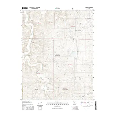
2015 Map of Bloodland
USGS Topo · Published 2015About this map
Fort Leonard Wood and the Mark Twain National Forest define the landscape of this Pulaski County region. The winding course of Roubidoux Creek cuts through the terrain, creating sharp elevations like the Devils Backbone. This 2015 survey shows the coexistence of military infrastructure, such as the Waynesville-St. Robert Regional Forney Field, alongside established local communities. Genealogists can locate several burial sites within these lands, including Friendship Cemetery, Clark Cemetery, McCann Cemetery, and the Bloodland Cemetery. The settlement of Bloodland sits at a junction of local routes, while Hanna and Cookville anchor the western and southern reaches of the map respectively. Numerous geographic hollows, from Ballard Hollow to Wildcat Hollow, illustrate the intricate drainage patterns that have shaped movement through these Ozark highlands for generations.
Find a feature on this map
32 named features on this map. Tap any name to fly to it.
Don’t see what you’re looking for? This feature index may not catch every label — zoom into the map to look around manually.
Map Details
Editions of this 2015 Bloodland Map
This is the sole edition of this map. No revisions or reprints were ever made.
Other maps of this area

1936 · Waynesville
USGS Topo · 1:48,000

1941 · Big Piney
USGS Topo · 1:62,500

1942 · Waynesville
USGS Topo · 1:62,500

1943 · Richland
USGS Topo · 1:62,500

1943 · Big Piney
USGS Topo · 1:62,500

1943 · Drynob
USGS Topo · 1:62,500

1944 · Waynesville
USGS Topo · 1:62,500

1954 · Springfield
USGS Topo · 1:250,000

1954 · Drynob
USGS Topo · 1:62,500
1954 · Big Piney
USGS Topo · 1:62,500