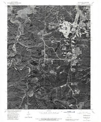
1976 Map of Bloodland
USGS Topo · Published 1980About this map
Bloodland and its surrounding countryside are captured in this 1976 orthophotoquad, which overlays land lines from a 1954 survey onto a mid-1970s aerial perspective. The landscape is defined by the sharp contrast between the densely wooded, winding drainage of Roubidoux Creek and the heavy development of the Fort Leonard Wood military reservation in the northeast. This specialized map format allows for the direct observation of forest density, road networks, and clearing patterns that standard topographic lines might obscure. The imagery shows the intersection of military infrastructure with the rugged Ozark terrain, revealing the footprint of mid-century training grounds and tactical routes adjacent to the established settlement at Bloodland. This document provides a clear view of the land's transition during a period of significant military activity and rural change in Pulaski County.
Find a feature on this map
3 named features on this map. Tap any name to fly to it.
Don’t see what you’re looking for? This feature index may not catch every label — zoom into the map to look around manually.
Map Details
Editions of this 1976 Bloodland Map
This is the sole edition of this map. No revisions or reprints were ever made.
Other maps of this area

1936 · Waynesville
USGS Topo · 1:48,000

1941 · Big Piney
USGS Topo · 1:62,500

1942 · Waynesville
USGS Topo · 1:62,500

1943 · Richland
USGS Topo · 1:62,500

1943 · Big Piney
USGS Topo · 1:62,500

1943 · Drynob
USGS Topo · 1:62,500

1944 · Waynesville
USGS Topo · 1:62,500

1954 · Springfield
USGS Topo · 1:250,000

1954 · Drynob
USGS Topo · 1:62,500
1954 · Big Piney
USGS Topo · 1:62,500