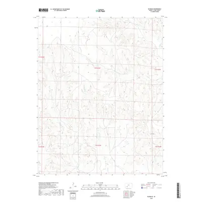
2018 Map of Bloom SE
USGS Topo · Published 2018About this map
Mt Nebo stands as a prominent elevation in this corner of Clark County, overlooking a landscape defined by the drainage patterns of the Cimarron River watershed. The terrain is deeply incised by several seasonal watercourses, including Bluff Cr in the northeast and Hackberry Cr, which winds through the central sections. These drainage systems create a complex topography of ridges and draws characteristic of the High Plains transition.
Find a feature on this map
17 named features on this map. Tap any name to fly to it.
Don’t see what you’re looking for? This feature index may not catch every label — zoom into the map to look around manually.
Map Details
Editions of this 2018 Bloom SE Map
This is the sole edition of this map. No revisions or reprints were ever made.
Other maps of this area

1894 · Sitka
USGS Topo · 1:62,500

1896 · Ashland
USGS Topo · 1:125,000

1955 · Pratt
USGS Topo · 1:250,000

1959 · Pratt
USGS Topo · 1:250,000

1967 · Bloom
USGS Topo · 1:24,000

1972 · Ashland NW
USGS Topo · 1:24,000
1972 · Ashland
USGS Topo · 1:24,000

1979 · Sitka
USGS Topo · 1:24,000

1979 · Bloom SE
USGS Topo · 1:24,000
1979 · Simmons Creek
USGS Topo · 1:24,000