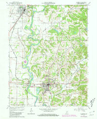
1966 Map of Bloomfield
USGS Topo · Published 1981About this map
Bloomfield and Worthington anchor this survey of the White River valley, where the waterway's serpentine oxbows and the Rock Riffle define the low-lying terrain between Jefferson and Richland townships. The map documents a landscape deeply shaped by transportation and resource extraction, notably the concentration of Gas Wells and a Pumping Sta near Rincon. The legacy of early settlement is visible in the numerous family-named burial grounds like Stalcup Cem and Bucher Cem, alongside rural landmarks such as Indian Mound. The confluence of the Eel River and White River at Point Commerce highlights the area's historical importance as a river junction, even as the Conrail and Illinois Central Gulf rail lines took over the movement of goods in the mid-20th century. Smaller communities like Hashtown and Elliston cluster near the rails and river, illustrating the settlement patterns of Greene County.
Find a feature on this map
51 named features on this map. Tap any name to fly to it.
Don’t see what you’re looking for? This feature index may not catch every label — zoom into the map to look around manually.
Map Details
Editions of this 1966 Bloomfield Map
2 editions found
Other maps of this area

1908 · Bloomfield
USGS Topo · 1:62,500

1938 · Coal City
USGS Topo · 1:24,000

1938 · Switz City
USGS Topo · 1:24,000

1943 · Lyons
USGS Topo · 1:24,000

1947 · Switz City
USGS Topo · 1:24,000

1948 · Coal City
USGS Topo · 1:24,000

1950 · Arney
USGS Topo · 1:24,000

1950 · Switz City
USGS Topo · 1:24,000

1951 · Bloomfield
USGS Topo · 1:24,000
1953 · Coal City
USGS Topo · 1:24,000