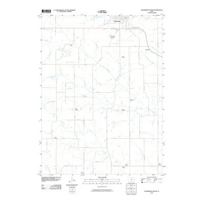
2010 Map of Bloomfield South
USGS Topo · Published 2010About this map
Lake Fisher and the southern outskirts of Bloomfield anchor this rural Davis County landscape, where the agricultural grid is punctuated by numerous family and community burial grounds. This territory is defined by the winding paths of the South Wyaconda River and the North Fabius River, which cut across a network of gravel roads and section lines. The abundance of cemeteries, such as Pollard Cemetery, Sullivan Cemetery, and Patterson Cemetery, provides a dense map of early settlement patterns for genealogists and local historians. To the west, Wesley Chapel Cemetery stands near the headwaters of Carter Creek, while the Bloomfield Municipal Airport marks a modern utility in an otherwise traditional farming region. These details reveal the enduring structure of Iowa's southern borderlands, where small communities like Steuben and scattered rural landmarks persist decades after their establishment.
Find a feature on this map
41 named features on this map. Tap any name to fly to it.
Don’t see what you’re looking for? This feature index may not catch every label — zoom into the map to look around manually.
Map Details
Editions of this 2010 Bloomfield South Map
This is the sole edition of this map. No revisions or reprints were ever made.
Other maps of this area

1954 · Centerville
USGS Topo · 1:250,000

1956 · Ottumwa South
USGS Topo · 1:62,500

1957 · Centerville
USGS Topo · 1:250,000

1958 · Centerville
USGS Topo · 1:250,000
1968 · Paris
USGS Topo · 1:24,000
1979 · West Grove
USGS Topo · 1:24,000
1979 · Floris
USGS Topo · 1:24,000
1979 · Pulaski
USGS Topo · 1:24,000
1979 · Lancaster
USGS Topo · 1:24,000
1979 · Bloomfield South
USGS Topo · 1:24,000