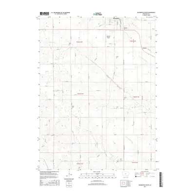
2015 Map of Bloomfield South
USGS Topo · Published 2015About this map
Bloomfield serves as the focal point for this southern Iowa landscape, where the town's southern edge transitions into a dense network of family-held farmstead sections. The terrain is deeply etched by a complex drainage system, primarily the S Wyaconda River and N Wyaconda River, alongside smaller tributaries like Carter Cr. This hydrology has historically dictated the placement of rural cemeteries and the winding paths of roads like Linseed Rd and 232nd Trl, which deviate from the standard cardinal grid.
Find a feature on this map
66 named features on this map. Tap any name to fly to it.
Don’t see what you’re looking for? This feature index may not catch every label — zoom into the map to look around manually.
Map Details
Editions of this 2015 Bloomfield South Map
This is the sole edition of this map. No revisions or reprints were ever made.
Other maps of this area

1954 · Centerville
USGS Topo · 1:250,000

1956 · Ottumwa South
USGS Topo · 1:62,500

1957 · Centerville
USGS Topo · 1:250,000

1958 · Centerville
USGS Topo · 1:250,000
1968 · Paris
USGS Topo · 1:24,000
1979 · West Grove
USGS Topo · 1:24,000
1979 · Floris
USGS Topo · 1:24,000
1979 · Pulaski
USGS Topo · 1:24,000
1979 · Lancaster
USGS Topo · 1:24,000
1979 · Bloomfield South
USGS Topo · 1:24,000