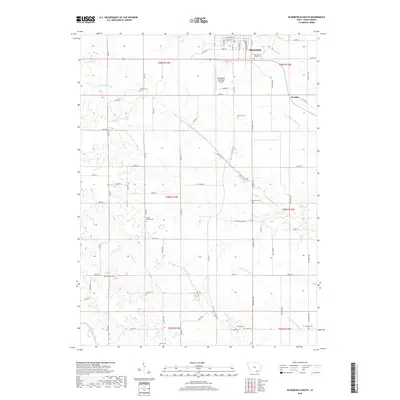
2018 Map of Bloomfield South
USGS Topo · Published 2018About this map
Bloomfield serves as the northern anchor for this rural landscape in Davis County, where the town’s grid gives way to a sprawling network of family-named cemeteries and winding watercourses. The drainage of the S Wyaconda River and Carter Cr dictates the local topography, while the N Fork Fabius River cuts through the southern reaches. Numerous burial grounds, including Pollard Cem, Sullivan Cem, and Patterson Cem, are scattered across the townships, offering significant points of interest for genealogists tracing early settlement patterns. Beyond the main town, the small community of Steuben is situated near the riverbanks, and the Bloomfield Municipal Airport stands as a modern landmark. The map detail highlights the intersection of traditional agricultural land divisions and the natural flow of the southern Iowa tributaries.
Find a feature on this map
67 named features on this map. Tap any name to fly to it.
Don’t see what you’re looking for? This feature index may not catch every label — zoom into the map to look around manually.
Map Details
Editions of this 2018 Bloomfield South Map
This is the sole edition of this map. No revisions or reprints were ever made.
Other maps of this area

1954 · Centerville
USGS Topo · 1:250,000

1956 · Ottumwa South
USGS Topo · 1:62,500

1957 · Centerville
USGS Topo · 1:250,000

1958 · Centerville
USGS Topo · 1:250,000
1968 · Paris
USGS Topo · 1:24,000
1979 · West Grove
USGS Topo · 1:24,000
1979 · Floris
USGS Topo · 1:24,000
1979 · Pulaski
USGS Topo · 1:24,000
1979 · Lancaster
USGS Topo · 1:24,000
1979 · Bloomfield South
USGS Topo · 1:24,000