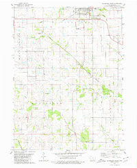
1979 Map of Bloomfield South
USGS Topo · Published 1980About this map
Bloomfield anchors this survey of southern Davis County, where the agricultural landscape is defined by the winding paths of the South Wyaconda River and Carter Creek. The town shows its mid-century infrastructure through the Bloomfield Municipal Airport and a Sewage Disposal plant, while the transition in transportation is evident along the Norfolk and Western line and a stretch of Old Railroad Grade. This map is particularly valuable for genealogical research, documenting numerous rural burying grounds such as Pollard Cem, Wesley Chapel Cem, and Dooley Cem that dot the townships of Wyacondah and Cleveland. The terrain shifts from the developed streets of the county seat to the wooded riparian corridors of the Fabius R in the far southwest, illustrating the persistent rural character of the Iowa borderlands during the late 1970s.
Find a feature on this map
23 named features on this map. Tap any name to fly to it.
Don’t see what you’re looking for? This feature index may not catch every label — zoom into the map to look around manually.
Map Details
Editions of this 1979 Bloomfield South Map
2 editions found
Other maps of this area

1954 · Centerville
USGS Topo · 1:250,000

1956 · Ottumwa South
USGS Topo · 1:62,500

1957 · Centerville
USGS Topo · 1:250,000

1958 · Centerville
USGS Topo · 1:250,000
1968 · Paris
USGS Topo · 1:24,000
1979 · West Grove
USGS Topo · 1:24,000
1979 · Floris
USGS Topo · 1:24,000
1979 · Pulaski
USGS Topo · 1:24,000
1979 · Lancaster
USGS Topo · 1:24,000
1980 · Bloomfield North
USGS Topo · 1:24,000