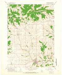
1962 Map of Bloomington
USGS Topo · Published 1964About this map
Military Ridge and Campbell Ridge dictate the geography of this corner of Grant County, creating a deeply dissected upland where roads often follow the high ground to avoid the sharp descents into stream valleys. The village of Patch Grove sits centrally, supported by institutional landmarks like the West Grant High Sch and a cluster of local burial grounds including Union Cem and St Johns Cem. The landscape is a network of ridges and drainage systems, where Warner Creek and Lane Creek cut through the northern townships while Blake Fork and Rattlesnake Creek define the southern reaches.
Find a feature on this map
27 named features on this map. Tap any name to fly to it.
Don’t see what you’re looking for? This feature index may not catch every label — zoom into the map to look around manually.
Map Details
Editions of this 1962 Bloomington Map
2 editions found
Other maps of this area

1900 · Lancaster
USGS Topo · 1:125,000

1902 · Elkader
USGS Topo · 1:125,000

1903 · Waukon
USGS Topo · 1:125,000

1904 · Lancaster
USGS Topo · 1:125,000

1908 · Lancaster
USGS Topo · 1:125,000

1926 · Wauzeka
USGS Topo · 1:62,500

1929 · Prairie Du Chien
USGS Topo · 1:62,500

1932 · Prairie Du Chien
USGS Topo · 1:62,500

1958 · La Crosse
USGS Topo · 1:250,000

1959 · Dubuque
USGS Topo · 1:250,000