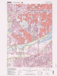
1997 Map of Bloomington
USGS Topo · Published 1999About this map
Bloomington and its neighboring suburbs of Edina, Richfield, and Burnsville are shown here as a mature metropolitan landscape in the late 1990s. The map illustrates a densely developed residential and commercial region, anchored by the massive Southtown Shopping Center and a complex web of highway interchanges. To the south, the industrial and transport infrastructure follows the Minnesota River, featuring the grain terminals of Port Cargill and the sprawling Black Dog Lake cooling pond for the nearby powerplant. This area serves as a stark transition between the suburban sprawl and the protected wetlands of the Minnesota Valley. Significant institutional landmarks are present, including the Minnesota Masonic Home and the Minnesota Valley Country Club, while local history is preserved at the Bloomington Cem and the Pleasant View Mem Gardens.
Find a feature on this map
111 named features on this map. Tap any name to fly to it.
Don’t see what you’re looking for? This feature index may not catch every label — zoom into the map to look around manually.
Map Details
Editions of this 1997 Bloomington Map
This is the sole edition of this map. No revisions or reprints were ever made.
Other maps of this area

1896 · Minneapolis
USGS Topo · 1:62,500

1896 · St. Paul
USGS Topo · 1:62,500

1901 · Minneapolis
USGS Topo · 1:62,500

1951 · St. Paul West
USGS Topo · 1:24,000

1951 · St. Paul SW
USGS Topo · 1:24,000

1951 · St. Paul
USGS Topo · 1:62,500

1952 · Minneapolis South
USGS Topo · 1:24,000

1953 · Saint Paul
USGS Topo · 1:250,000

1954 · Hopkins
USGS Topo · 1:24,000

1954 · Bloomington
USGS Topo · 1:24,000