
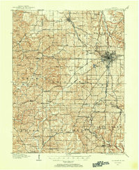
1908 Map of Bloomington
USGS Topo · Published 1908About this map
Bloomington serves as the focal point of this 1908 advance sheet, appearing just as the city and Indiana University were expanding into the surrounding hills of Monroe County. The map captures a landscape defined by a dense network of early 20th-century rural infrastructure, including a high concentration of named schools like Hardscrabble School and Vernal School and churches such as Bethlehem Church.
Find a feature on this map
54 named features on this map. Tap any name to fly to it.
Don’t see what you’re looking for? This feature index may not catch every label — zoom into the map to look around manually.
Map Details
Editions of this 1908 Bloomington Map
2 editions found
Other maps of this area

1908 · Bloomfield
USGS Topo · 1:62,500

1910 · Bloomington
USGS Topo · 1:62,500

1934 · Bedford
USGS Topo · 1:48,000

1935 · Oolitic
USGS Topo · 1:48,000

1937 · Bedford
USGS Topo · 1:62,500

1942 · Franklin
USGS Topo · 1:125,000

1942 · Oolitic
USGS Topo · 1:62,500

1947 · Allens Creek
USGS Topo · 1:24,000

1947 · Unionville
USGS Topo · 1:24,000

1947 · Gosport
USGS Topo · 1:24,000