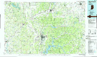
1986 Map of Bloomington
USGS Topo · Published 1986About this map
Indiana University serves as a major anchor for Bloomington, a regional hub defined by its complex network of reservoirs and protected woodlands. This mid-1980s landscape reveals the scale of Monroe Lake and Cataract Lake, which transformed the local topography and recreation patterns. The map detail highlights the convergence of heavy transit and military footprints, from the Illinois Central Gulf RR corridors to the sprawling Camp Atterbury Military Reservation in the northeast.
Find a feature on this map
255 named features on this map. Tap any name to fly to it.
Don’t see what you’re looking for? This feature index may not catch every label — zoom into the map to look around manually.
Map Details
Editions of this 1986 Bloomington Map
3 editions found
Other maps of this area

1908 · Clay City
USGS Topo · 1:48,000

1908 · Bloomington
USGS Topo · 1:48,000

1908 · Bloomfield
USGS Topo · 1:62,500

1910 · Clay City
USGS Topo · 1:62,500

1910 · Bloomington
USGS Topo · 1:62,500

1934 · Bedford
USGS Topo · 1:48,000

1935 · Oolitic
USGS Topo · 1:48,000

1937 · Bedford
USGS Topo · 1:62,500

1938 · Coal City
USGS Topo · 1:24,000

1938 · Switz City
USGS Topo · 1:24,000