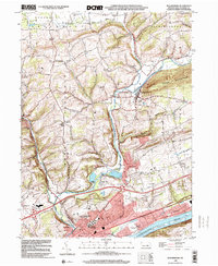
1999 Map of Bloomsburg
USGS Topo · Published 2001About this map
Bloomsburg dominates this area of Columbia County, where the historic town center and the State Teachers College campus sit just north of the Susquehanna River. The landscape follows the winding path of Fishing Creek, which descends through Pleasant Valley and turns south between Turkey Hill and the community of Light Street. This corridor shows a mix of educational infrastructure, industry at Paper Mill, and recreational spaces like Camp Creasy.
Find a feature on this map
48 named features on this map. Tap any name to fly to it.
Don’t see what you’re looking for? This feature index may not catch every label — zoom into the map to look around manually.
Map Details
Editions of this 1999 Bloomsburg Map
This is the sole edition of this map. No revisions or reprints were ever made.
Other maps of this area

1889 · Catawissa
USGS Topo · 1:62,500

1892 · Catawissa
USGS Topo · 1:62,500

1892 · Shamokin
USGS Topo · 1:62,500

1893 · Shamokin
USGS Topo · 1:62,500

1894 · Catawissa
USGS Topo · 1:62,500

1894 · Bloomsburg
USGS Topo · 1:62,500

1935 · Hughesville
USGS Topo · 1:62,500

1943 · Shamokin
USGS Topo · 1:62,500

1947 · Bloomsburg
USGS Topo · 1:24,000

1947 · Stillwater
USGS Topo · 1:24,000
Featured Places
- Bloomsburg, PA
- Greenwood Township, PA
- North Centre Township, PA
- Lightstreet, Scott Township
- Orangeville, PA