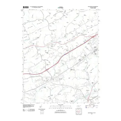
2010 Map of Blountville
USGS Topo · Published 2010About this map
Blountville and its surrounding countryside are captured here in a period of modern growth that preserves deep ties to its 18th-century roots. The Blountville Historic District serves as the focal point, anchoring a landscape where historical landmarks like the Galloway Mill stand near the high-speed infrastructure of the Bristol International Speedway. The geography is defined by a dense network of family-named ridges and hollows, such as Latture Ridge and Carden Hollow, which have dictated the layout of rural roads and small settlements like Buncombe and Leonardtown. Genealogists will find the terrain heavily marked by local family history, indicated by the numerous cemeteries scattered across the ridges, including Pullen Cemetery, Faulkner Cemetery, and Staubus Cemetery. Water features such as Boozy Creek and Beaver Creek wind through the valleys, illustrating the natural drainage patterns that historically shaped the placement of farms and early industry in this portion of Northeast Tennessee.
Find a feature on this map
162 named features on this map. Tap any name to fly to it.
Don’t see what you’re looking for? This feature index may not catch every label — zoom into the map to look around manually.
Map Details
Editions of this 2010 Blountville Map
This is the sole edition of this map. No revisions or reprints were ever made.
Other maps of this area

1891 · Roan Mountain
USGS Topo · 1:125,000

1894 · Roan Mountain
USGS Topo · 1:125,000

1897 · Bristol
USGS Topo · 1:125,000

1902 · Bristol
USGS Topo · 1:125,000

1904 · Roan Mountain
USGS Topo · 1:125,000

1934 · Wallace
USGS Topo · 1:24,000

1934 · Bristol
USGS Topo · 1:24,000

1935 · Hilton
USGS Topo · 1:24,000

1935 · Watauga Valley
USGS Topo · 1:48,000

1935 · Mendota
USGS Topo · 1:24,000