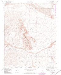
1972 Map of Blue Diamond SE
USGS Topo · Published 1982About this map
The Union Pacific Railroad corridor south of Las Vegas dominates this desert landscape, tracing a path alongside the settlement at Bard. During the early 1970s and subsequent revisions, this region was characterized by industrial extraction and the early westward expansion of the suburban grid. Numerous Mines, Mine sites, and Prospects are scattered across the higher elevations, while the flatter terrain to the east shows the emergence of named thoroughfares like Flamingo Rd and Tropicana Ave. The presence of an Old Railroad Grade and several Dry Wells highlights the historical challenge of water management and transport in this arid environment. Significant infrastructure is evident in the Pipeline corridors and the Union Pacific Road, reflecting a landscape transitioning from isolated mining claims to an organized logistical and residential network defined by the drainage of Tropicana Wash.
Find a feature on this map
22 named features on this map. Tap any name to fly to it.
Don’t see what you’re looking for? This feature index may not catch every label — zoom into the map to look around manually.
Map Details
Editions of this 1972 Blue Diamond SE Map
2 editions found
Other maps of this area

1907 · Las Vegas
USGS Topo · 1:250,000

1908 · Las Vegas
USGS Topo · 1:250,000

1910 · Ivanpah
USGS Topo · 1:250,000

1912 · Ivanpah
USGS Topo · 1:250,000

1942 · Ivanpah
USGS Topo · 1:250,000

1947 · Kingman
USGS Topo · 1:250,000

1948 · Kingman
USGS Topo · 1:250,000

1952 · Blue Diamond
USGS Topo · 1:62,500

1952 · Las Vegas
USGS Topo · 1:62,500

1954 · Las Vegas
USGS Topo · 1:250,000