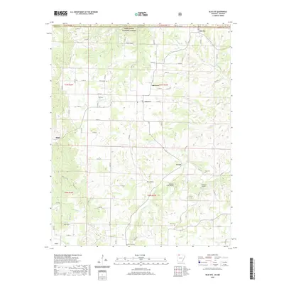
2020 Map of Blue Eye
USGS Topo · Published 2020About this map
Blue Eye straddles the boundary between Carroll County, Arkansas, and Stone County, Missouri, serving as a focal point for this Ozark Highland landscape. The terrain is deeply dissected by drainage systems including Yocum Cr, Indian Cr, and Stillhouse Cr, which carve out notable depressions such as Allen Hollow and Buzzard Roost Hollow. A significant portion of the northern reach is protected within the Mark Twain National Forest, while the southern area features the prominent rise of Pilot Knob. Small settlements and crossroads like Oakgrove, Maple, and Cisco are connected by a network of county roads. For those researching local history, the map identifies several rural burial sites, including Hale Cem near Little Indian Cr and Boyd Cem further north. Natural water sources are a defining characteristic, with Blue Spring, Hall Spring, and Hammond Spring punctuating the winding valley floors.
Find a feature on this map
89 named features on this map. Tap any name to fly to it.
Don’t see what you’re looking for? This feature index may not catch every label — zoom into the map to look around manually.
Map Details
Editions of this 2020 Blue Eye Map
This is the sole edition of this map. No revisions or reprints were ever made.
Other maps of this area

1900 · Eureka Springs
USGS Topo · 1:125,000

1901 · Eureka Springs
USGS Topo · 1:125,000

1904 · Harrison
USGS Topo · 1:125,000

1905 · Harrison
USGS Topo · 1:125,000

1907 · Forsyth
USGS Topo · 1:125,000

1927 · Shell Knob
USGS Topo · 1:62,500

1945 · Harrison
USGS Topo · 1:250,000

1949 · Harrison
USGS Topo · 1:250,000

1950 · Shell Knob
USGS Topo · 1:62,500

1954 · Harrison
USGS Topo · 1:250,000