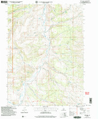
2001 Map of Blue Hill
USGS Topo · Published 2006About this map
The California National Historic Trail (Applegate) cuts through the southern reaches of this landscape, marking a path used by nineteenth-century emigrants through the high desert. Much of the western terrain is protected within the Sawtooth National Forest, characterized by deep incisions like Big Canyon and Day Canyon. Water is the defining resource for this area, evidenced by the numerous named water sources such as Coal Banks Spring, Poulton Spring, and Worthington Spring that dot the arid basins.
Find a feature on this map
34 named features on this map. Tap any name to fly to it.
Don’t see what you’re looking for? This feature index may not catch every label — zoom into the map to look around manually.
Map Details
Editions of this 2001 Blue Hill Map
This is the sole edition of this map. No revisions or reprints were ever made.
Other maps of this area

1954 · Pocatello
USGS Topo · 1:250,000

1954 · Brigham City
USGS Topo · 1:250,000

1955 · Twin Falls
USGS Topo · 1:250,000

1955 · Wells
USGS Topo · 1:250,000

1958 · Wells
USGS Topo · 1:250,000

1958 · Twin Falls
USGS Topo · 1:250,000

1958 · Pocatello
USGS Topo · 1:250,000

1958 · Brigham City
USGS Topo · 1:250,000

1959 · Cotton Thomas Basin
USGS Topo · 1:62,500

1961 · Wells
USGS Topo · 1:250,000