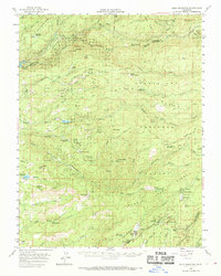
1956 Map of Blue Mountain
USGS Topo · Published 1970About this map
Stanislaus National Forest and Eldorado National Forest meet here amidst the deep drainage systems of the Mokelumne River and the North Fork Stanislaus River. This mid-century landscape is defined by the lumber industry and high-elevation ranching, evidenced by several processing locations such as Mitchells Mill (Site), Manuel Mill (Site), and Touch Mill (Site). The timber economy is further represented by Lumber Camp outposts and the White Pines community.
Find a feature on this map
91 named features on this map. Tap any name to fly to it.
Don’t see what you’re looking for? This feature index may not catch every label — zoom into the map to look around manually.
Map Details
Editions of this 1956 Blue Mountain Map
3 editions found
Other maps of this area

1889 · Jackson
USGS Topo · 1:125,000

1889 · Pyramid Peak
USGS Topo · 1:125,000

1891 · Big Trees
USGS Topo · 1:125,000

1891 · Placerville
USGS Topo · 1:125,000

1891 · Pyramid Peak
USGS Topo · 1:125,000

1892 · Jackson
USGS Topo · 1:125,000

1892 · Placerville
USGS Topo · 1:125,000

1893 · Placerville
USGS Topo · 1:125,000

1894 · Big Trees
USGS Topo · 1:125,000

1895 · Pyramid Peak
USGS Topo · 1:125,000