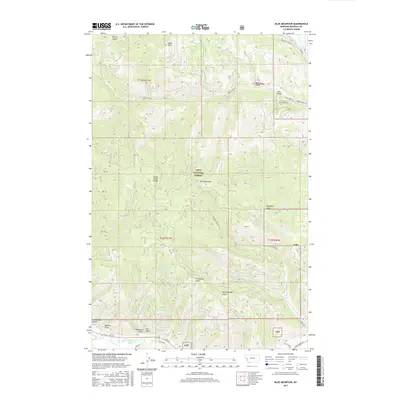
2017 Map of Blue Mountain
USGS Topo · Published 2017About this map
Lolo sits at the eastern edge of this Missoula County landscape, where the waters of Lolo Creek and the Clark Fork river converge near the Big Flat Ditch. The terrain is dominated by the ridges of the Grave Creek Range and the high points of Blue Mountain and Black Mtn, much of which is protected within the Lolo National Forest. This 2017 survey details the complex network of drainage and local transit, with named features such as Schoolhouse Gulch and Mailbox Gulch hinting at the rural settlement patterns in the valley. The map documents modern forest access through routes like Obrien Creek Rd and Sleeman Creek Rd, alongside numerous timber and pack trails. The presence of several legacy land parcels, including PB 38 and PB 43, provides a view of property boundaries that persist alongside the vast public lands of the national forest system.
Find a feature on this map
49 named features on this map. Tap any name to fly to it.
Don’t see what you’re looking for? This feature index may not catch every label — zoom into the map to look around manually.
Map Details
Editions of this 2017 Blue Mountain Map
This is the sole edition of this map. No revisions or reprints were ever made.
Other maps of this area

1912 · Missoula
USGS Topo · 1:125,000

1956 · Hamilton
USGS Topo · 1:250,000

1959 · Hamilton
USGS Topo · 1:250,000

1960 · Hamilton
USGS Topo · 1:250,000

1963 · Primrose
USGS Topo · 1:24,000

1964 · Hamilton
USGS Topo · 1:250,000
1964 · Diamond Point
USGS Topo · 1:24,000

1964 · Dick Creek
USGS Topo · 1:24,000
1964 · Northwest Missoula
USGS Topo · 1:24,000
1964 · Blue Mountain
USGS Topo · 1:24,000