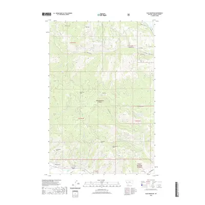
2020 Map of Blue Mountain
USGS Topo · Published 2020About this map
The Lolo National Forest dominates this mountain landscape, where the Grave Creek Range and the summit of Blue Mtn rise above a complex network of drainages and gulches. The terrain is characterized by steep ridges and deep valleys, including Black Mtn in the north and several named canyons like Schoolhouse Gulch and Chickaman Gulch to the south. Human activity and access are defined by a mix of primitive trails and established roads, such as Obrien Creek Rd and the Jeep Trl, which navigate the rugged topography.
Find a feature on this map
41 named features on this map. Tap any name to fly to it.
Don’t see what you’re looking for? This feature index may not catch every label — zoom into the map to look around manually.
Map Details
Editions of this 2020 Blue Mountain Map
This is the sole edition of this map. No revisions or reprints were ever made.
Other maps of this area

1912 · Missoula
USGS Topo · 1:125,000

1956 · Hamilton
USGS Topo · 1:250,000

1959 · Hamilton
USGS Topo · 1:250,000

1960 · Hamilton
USGS Topo · 1:250,000

1963 · Primrose
USGS Topo · 1:24,000

1964 · Hamilton
USGS Topo · 1:250,000
1964 · Diamond Point
USGS Topo · 1:24,000

1964 · Dick Creek
USGS Topo · 1:24,000
1964 · Northwest Missoula
USGS Topo · 1:24,000
1964 · Blue Mountain
USGS Topo · 1:24,000