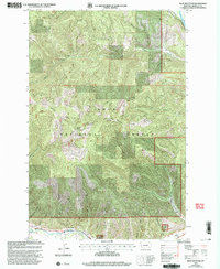
1999 Map of Blue Mountain
USGS Topo · Published 2003About this map
Lolo National Forest dominates this landscape southwest of Missoula, where the high ridges of the Grave Creek Range and peaks like Blue Mountain and Black Mountain define the terrain. The southern edge of the map follows the corridor of Lolo Creek, a vital historical passage marked by the paths of the Lolo Trail and the Lewis and Clark Nat Hist Trail. These routes signify the area's deep history as a transit point through the Bitterroot Mountains.
Find a feature on this map
28 named features on this map. Tap any name to fly to it.
Don’t see what you’re looking for? This feature index may not catch every label — zoom into the map to look around manually.
Map Details
Editions of this 1999 Blue Mountain Map
This is the sole edition of this map. No revisions or reprints were ever made.
Other maps of this area

1912 · Missoula
USGS Topo · 1:125,000

1956 · Hamilton
USGS Topo · 1:250,000

1959 · Hamilton
USGS Topo · 1:250,000

1960 · Hamilton
USGS Topo · 1:250,000

1963 · Primrose
USGS Topo · 1:24,000

1964 · Hamilton
USGS Topo · 1:250,000
1964 · Diamond Point
USGS Topo · 1:24,000

1964 · Dick Creek
USGS Topo · 1:24,000
1964 · Northwest Missoula
USGS Topo · 1:24,000
1964 · Blue Mountain
USGS Topo · 1:24,000