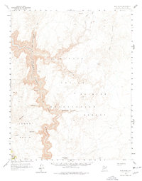
1955 Map of Blue Spring
USGS Topo · Published 1978About this map
Little Colorado River carves a deep, winding path through this corner of the Navajo Indian Reservation during the mid-1950s. The landscape is defined by its dramatic hydrology, featuring the eponymous Blue Spring and a series of tributary drainages like Waterhole Canyon and Salt Trail Canyon. The terrain transitions from the high elevations of Pillow Mtn in the north toward the open expanse of the Painted Desert in the southeast, revealing a complex network of gorges and washes. Geodetic markers like Black Rock and Gold Hill provide fixed points across a region largely devoid of permanent human settlements, instead showing the natural boundary where the reservation meets the eastern edge of the Kaibab Nat Forest.
Find a feature on this map
24 named features on this map. Tap any name to fly to it.
Don’t see what you’re looking for? This feature index may not catch every label — zoom into the map to look around manually.
Map Details
Editions of this 1955 Blue Spring Map
3 editions found

Other maps of this area

1886 · San Francisco Mtns
USGS Topo · 1:250,000

1886 · Echo Cliffs
USGS Topo · 1:250,000

1891 · San Francisco Mtns
USGS Topo · 1:250,000

1891 · Echo Cliffs
USGS Topo · 1:250,000

1894 · San Francisco Mtns
USGS Topo · 1:250,000

1899 · San Francisco Mtns
USGS Topo · 1:250,000

1907 · Vishnu
USGS Topo · 1:48,000

1947 · Flagstaff
USGS Topo · 1:250,000

1954 · Shinumo Altar SE
USGS Topo · 1:24,000

1954 · Nankoweap
USGS Topo · 1:62,500