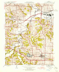
1945 Map of Blue Springs
USGS Topo · Published 1955About this map
Blue Springs and the surrounding Jackson County landscape appear here in the mid-1940s, revealing a mix of established rural agricultural patterns and significant industrial footprints. The most striking landmark is the massive Lake City Ordnance Plant in the northeast, which stands in contrast to the numerous one-room schoolhouses like Eureka Sch, Owens Sch, and Etna Sch that dot the countryside. The geography is defined by the winding course of the Little Blue River, which flows past the small community of Selsa and under the Chicago and Alton railroad tracks.
Find a feature on this map
44 named features on this map. Tap any name to fly to it.
Don’t see what you’re looking for? This feature index may not catch every label — zoom into the map to look around manually.
Map Details
Editions of this 1945 Blue Springs Map
This is the sole edition of this map. No revisions or reprints were ever made.
Other maps of this area

1887 · Harrisonville
USGS Topo · 1:125,000

1892 · Harrisonville
USGS Topo · 1:125,000

1894 · Harrisonville
USGS Topo · 1:125,000

1894 · Independence
USGS Topo · 1:125,000

1933 · Blue Springs
USGS Topo · 1:24,000

1934 · Oak Grove
USGS Topo · 1:24,000

1934 · Independence
USGS Topo · 1:24,000

1934 · Lees Summit
USGS Topo · 1:24,000

1934 · Woods Chapel
USGS Topo · 1:24,000

1935 · Buckner
USGS Topo · 1:24,000