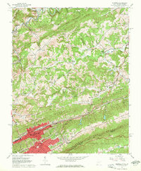
1962 Map of Bluefield
USGS Topo · Published 1972About this map
Bluefield and its surrounding mountain ridges appear here during a period of significant mid-century infrastructure, centered on the dominant Norfolk and Western rail corridor. The industrial and educational heart of the city is evident through landmarks like Bluefield State Teachers College and several local schools such as Genoa Sch and Park Central High Sch. Beyond the urban core, the landscape is defined by the steep topography of Beaver Pond Ridge and East River Mountain, which separate the city from outlying settlements like Ceres and Littlesburg. The presence of Old Ada Dam and the nearby Sewage Disposal and Filtration Plant indicate the complex water management systems required by the valley's geography. To the south, the Jefferson National Forest provides a stark contrast to the developed corridors, while family-named cemeteries such as Stowers Cem and Hager Cem are scattered across the lower ridges, documenting the long-standing community roots in the Appalachian plateau.
Find a feature on this map
109 named features on this map. Tap any name to fly to it.
Don’t see what you’re looking for? This feature index may not catch every label — zoom into the map to look around manually.
Map Details
Editions of this 1962 Bluefield Map
3 editions found
Other maps of this area

1887 · Pocahontas
USGS Topo · 1:125,000

1891 · Pocahontas
USGS Topo · 1:125,000

1894 · Pocahontas
USGS Topo · 1:125,000

1895 · Pocahontas
USGS Topo · 1:125,000

1909 · Pocahontas Special
USGS Topo · 1:48,000

1911 · Pocahontas Special
USGS Topo · 1:62,500

1913 · Bluefield
USGS Topo · 1:48,000

1916 · Bluefield
USGS Topo · 1:62,500

1924 · Bramwell
USGS Topo · 1:62,500

1924 · Bluefield
USGS Topo · 1:62,500