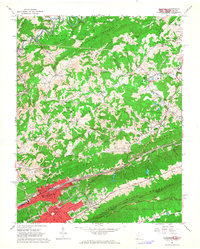
1962 Map of Bluefield
USGS Topo · Published 1964About this map
Bluefield serves as the industrial and educational anchor of this 1962 landscape, situated where the Norfolk and Western rail lines cut through the valley floor. The city's mid-century footprint includes Bluefield State Teachers College and several local schools like Ramsey Sch and Preston St Sch. To the north, the terrain transitions into a dense network of ridges such as Stony Ridge and Black Oak Mountain, punctuated by smaller residential clusters like Littlesburg and Glenwood.
Find a feature on this map
89 named features on this map. Tap any name to fly to it.
Don’t see what you’re looking for? This feature index may not catch every label — zoom into the map to look around manually.
Map Details
Editions of this 1962 Bluefield Map
3 editions found
Other maps of this area

1887 · Pocahontas
USGS Topo · 1:125,000

1891 · Pocahontas
USGS Topo · 1:125,000

1894 · Pocahontas
USGS Topo · 1:125,000

1895 · Pocahontas
USGS Topo · 1:125,000

1909 · Pocahontas Special
USGS Topo · 1:48,000

1911 · Pocahontas Special
USGS Topo · 1:62,500

1913 · Bluefield
USGS Topo · 1:48,000

1916 · Bluefield
USGS Topo · 1:62,500

1924 · Bramwell
USGS Topo · 1:62,500

1924 · Bluefield
USGS Topo · 1:62,500