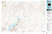
1994 Map of Bluejoint Lake
USGS Topo · Published 1994About this map
Warner Valley dominates this high desert landscape, characterized by a complex system of alkaline basins and dramatic fault-block topography. Central to the area is Bluejoint Lake, situated along the base of the prominent Poker Jim Ridge. The geography is defined by series of basins including the Catlow Valley and the Mule Springs Valley, separated by massive escarpments like the Abert Rim and Orejana Rim.
Find a feature on this map
107 named features on this map. Tap any name to fly to it.
Don’t see what you’re looking for? This feature index may not catch every label — zoom into the map to look around manually.
Map Details
Editions of this 1994 Bluejoint Lake Map
2 editions found
Other maps of this area

1955 · Crescent
USGS Topo · 1:250,000

1955 · Klamath Falls
USGS Topo · 1:250,000

1955 · Burns
USGS Topo · 1:250,000

1955 · Adel
USGS Topo · 1:250,000

1957 · Adel
USGS Topo · 1:250,000

1957 · Crescent
USGS Topo · 1:250,000

1958 · Crescent
USGS Topo · 1:250,000

1958 · Klamath Falls
USGS Topo · 1:250,000

1958 · Burns
USGS Topo · 1:250,000

1958 · Adel
USGS Topo · 1:250,000