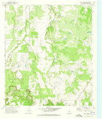
1973 Map of Bluff Creek
USGS Topo · Published 1976About this map
The Brady Mountains rise in the southern portion of this McCulloch County landscape, presenting a distinct topographical barrier that shapes the local drainage patterns. This 1973 survey captures a rural Texas environment defined by the winding course of Bluff Creek and its tributaries, including Cow Creek and the divided West Fork and East Fork. The terrain is marked by notable elevations such as Table Top Mountain and localized landmarks like China Tank. While primarily agricultural and pastoral, the map documents specific points of industrial activity through the labeling of Gravel Pits and a Gas Well, indicating the varied use of the land during the early 1970s. The network of unimproved roads and light-duty surfaces connecting these features illustrates a sparsely populated region where geography dictates the placement of transit and industry.
Find a feature on this map
9 named features on this map. Tap any name to fly to it.
Don’t see what you’re looking for? This feature index may not catch every label — zoom into the map to look around manually.
Map Details
Editions of this 1973 Bluff Creek Map
This is the sole edition of this map. No revisions or reprints were ever made.
Other maps of this area

1894 · Brady
USGS Topo · 1:125,000

1924 · Brady 2-a
USGS Topo · 1:48,000

1925 · Brady 2-b
USGS Topo · 1:48,000

1925 · Brady 1-b
USGS Topo · 1:48,000

1928 · Mercury
USGS Topo · 1:62,500

1928 · Waldrip
USGS Topo · 1:62,500

1950 · Mercury
USGS Topo · 1:62,500

1954 · Brownwood
USGS Topo · 1:250,000

1960 · West Sweden
USGS Topo · 1:24,000

1960 · Brady North
USGS Topo · 1:24,000