
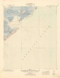
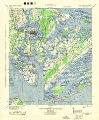
1945 Map of Bluffton
USGS Topo · Published 1945About this map
The coastal marshlands and sea islands of the South Carolina and Georgia border are captured here just as World War II came to a close. Centered on the intricate waterways of Calibogue Sound and the May River, the map reveals a maritime landscape defined by tidal creeks and isolated island communities. On Hilton Head Island, small settlements like Spanish Wells and Hickory Bluff are visible long before modern resort development, while the mainland village of Bluffton sits perched above the river. An Oyster Packing Plant on Mackay Creek points to the region's mid-century reliance on the harvest of the sea.
Find a feature on this map
79 named features on this map. Tap any name to fly to it.
Don’t see what you’re looking for? This feature index may not catch every label — zoom into the map to look around manually.
Map Details
Editions of this 1945 Bluffton Map
This is the sole edition of this map. No revisions or reprints were ever made.
Other maps of this area

1920 · Hardeeville
USGS Topo · 1:62,500

1920 · Okatie
USGS Topo · 1:62,500
1920 · Wassaw Sound
USGS Topo · 1:62,500

1920 · Hilton Head
USGS Topo · 1:62,500

1920 · Bluffton
USGS Topo · 1:62,500

1942 · Savannah
USGS Topo · 1:62,500

1942 · Okatie
USGS Topo · 1:62,500

1943 · Hardeeville
USGS Topo · 1:62,500
1944 · Fort Fremont
USGS Topo · 1:62,500

1944 · Ossabaw Island
USGS Topo · 1:62,500