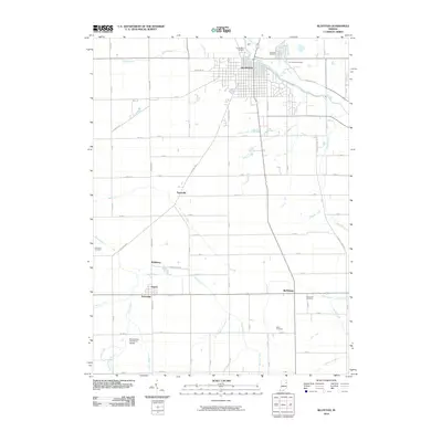
2010 Map of Bluffton
USGS Topo · Published 2010About this map
The Wabash River anchors this 2010 survey as it winds through the city of Bluffton, providing a natural boundary for the established neighborhoods and the outlying Elm Grove Cemetery. The landscape transitions from the urban grid of Bluffton south into an extensive network of managed agricultural drainage, marked by dozens of named channels such as Johnson Ditch, Markley Ditch, and Crosbie Ditch.
Find a feature on this map
56 named features on this map. Tap any name to fly to it.
Don’t see what you’re looking for? This feature index may not catch every label — zoom into the map to look around manually.
Map Details
Editions of this 2010 Bluffton Map
This is the sole edition of this map. No revisions or reprints were ever made.
Other maps of this area

1953 · Muncie
USGS Topo · 1:250,000

1955 · Markle
USGS Topo · 1:24,000

1956 · Muncie
USGS Topo · 1:250,000

1962 · Uniondale
USGS Topo · 1:24,000

1962 · Montpelier
USGS Topo · 1:24,000

1962 · Liberty Center
USGS Topo · 1:24,000

1962 · Preble
USGS Topo · 1:24,000

1962 · Petroleum
USGS Topo · 1:24,000

1962 · Linn Grove
USGS Topo · 1:24,000
1962 · Domestic
USGS Topo · 1:24,000